Forestry in New Brunswick < previous | 1 | 2 | 3 | 4 |
Approximately 85% of New Brunswick's land base is productive forest, providing wildlife habitat, landscape, recreational opportunities, and high-quality water and air. Forestry is the economic backbone of the province, directly employing 16,000 people, with wages of more than $500 million annually. Pulp production is valued at more than $1.5 billion each year, while solid wood products are worth about $500 million. Almost half the value of all exports from New Brunswick are derived from the forest. Unlike other regions of Canada where the Crown owns the vast majority of the forests, in the Maritimes a large proportion of these lands are privately owned.
Forest ownership in New Brunswick is distributed as follows: 30% is in private hands (usually woodlots on small parcels), 22% is in freehold (usually in relatively large parcels), and the remaining 48% is Crown land (mostly in immense tracts). For Canada as a whole private ownership makes up only about 6% of forest lands.
Private and freehold lands are owned by individuals and corporations. Crown lands are mostly allocated to multinational forest product companies managing them under 25 year leases. Crown and freehold lands are not where I expect to find the bulk of my potential clientele.
Instead I would expect most of my work to be with: woodlot owners interested in Low Impact Forestry; farmers wanting to incorporate agroforestry into their operations; and nonprofit organizations and community groups with environmental projects on either public or private lands. Examples of groups I would like to work with include the Southern New Brunswick Wood Co-op, and the Petitcodiac Riverkeeper.
Approximately 30% of the wood harvested in New Brunswick comes off of small private holdings. On the surface that would seem the expected share, since they are 30% of the province's forested lands. However, not all owners are cutting in their forests- many may be too small to make it economical, others are managing their land for different objectives. The fact that the potential gap has been closed indicates that the private woodlots that are being harvested are producing above average volumes as compared to freehold and Crown lands.
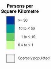
The different rate of production is not surprising however. The map at right showing Crown lands in green, is also effectively showing private and freehold lands in white. When compared to the population map above, and the elevation map below, one can see that private lands are concentrated along river valleys and lowlands. Historically, this is a typical pattern of rural development. Essentially the most productive lands were settled first, precisely because of their rich soils and favorable microclimates. What was left remained the property of the Crown. As agriculture declined and farmland reverted to forest, it stayed private, becoming woodlots and recreational properties.
From a forestry perspective small private woodlots are under more diverse management and often subject to more activity and value per acre than most Crown lands. This makes them an ideal area for work with properly managed stream crossings, riparian forest buffers, and Low Impact Forestry. Practices such as these maintain forest quality, thereby protecting property values and productivity.
That kind of long term self interest often motivates small private land owners to be good land stewards. Next door, in Maine, a recent study by the State Forest Service found that commercial landowners (industry owned or large land ownerships managed primarily for commercial timber production) only used such best management practices appropriately 31% of the time. Non-industrial private landowners used best management practices appropriately 46% of the time. In both cases there was room for improvement, however the small scale private owners seem more open to the adoption of improved practices.
The Provincial Government and Ducks Unlimited have recently partnered to help agricultural producers with projects related to water quality and biodiversity conservation. This Biodiversity Enhancement Program, will fund wetland construction and restoration, beaver pond management, and wildlife flushing bars. The opportunities for projects in New Brunswick appear to be numerous, and that is what attracts me to the province.
I don't want to be too dependent on public funding however. In the past British Columbia has been a magnet for business ventures similar to mine, except that the focus was on Crown lands. Much of the reason for that was a provincial initiative called Forest Renewal BC which had reasonably successful watershed and ecosystem restoration programs. However when the BC Liberal party replaced the NDP government in 2001 they ended FRBC, trading it in for a less active program of their own. While not personally affected by this turn of events, it does argue against investing resources, time, and effort into a market so dependent on a single source of funding. Particularly direct government funding, which can be sensitive to politics. Much better to look at many diverse smaller sources.
Aside from economics, a motivation for choosing to work in New Brunswick is the unique character of the Acadian forest. It is the zone where the eastern hardwood forests merge with northern boreal forests. In New Brunswick specifically, the vegetation types are mixing over an impressive range of elevations. As a result the province has the greatest diversity of forest communities and tree species occurring at that latitude across North America. There are 32 different species of trees in the Acadian forest, with softwoods such as white pine, red spruce, eastern hemlock, and northern white-cedar; as well as hardwoods like beech, northern red oak, black cherry, and white ash. That mix alone would make it a fascinating place to work.
< previous | 1 | 2 | 3 | 4 |